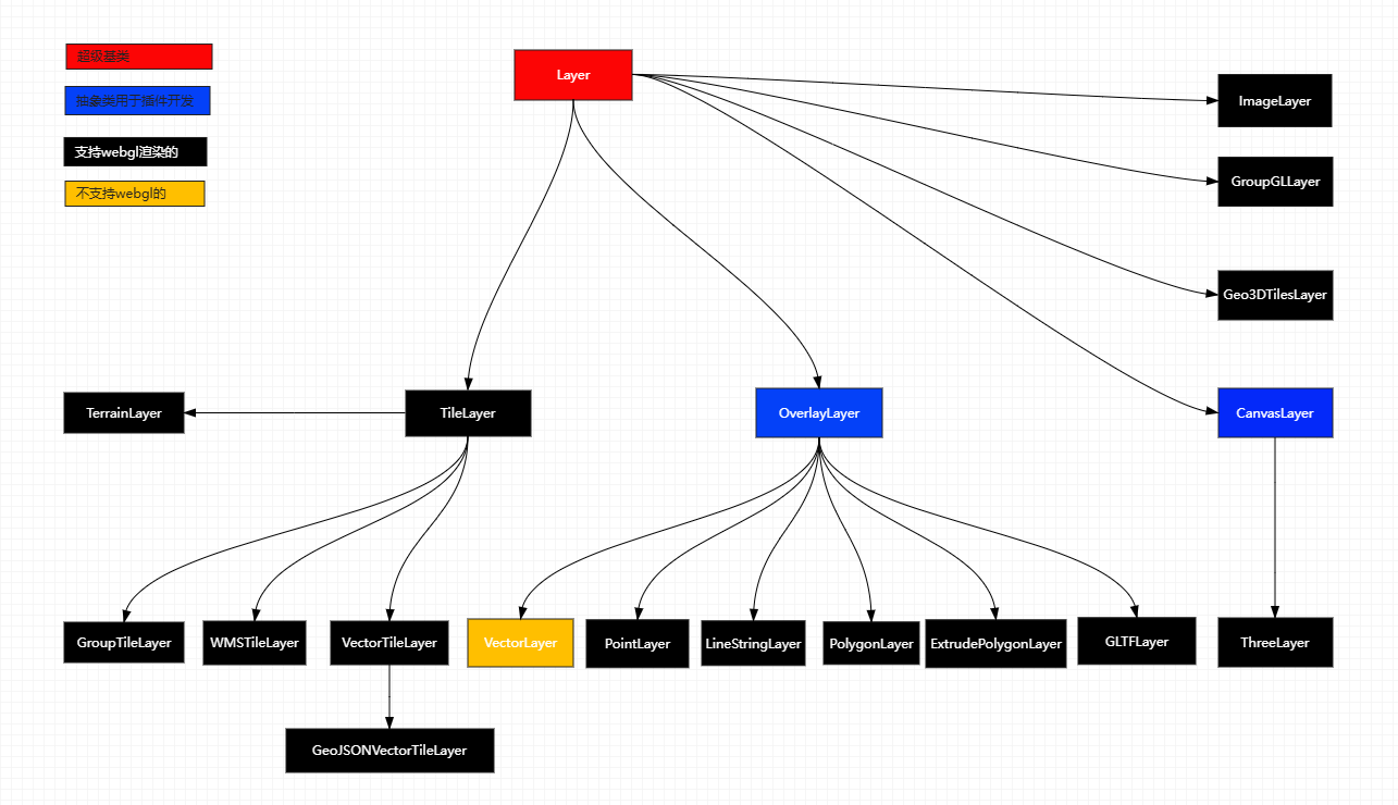
ThreeLayer
A maptalks Layer to render with three.js
It is based on maptalks.CanvasLayer
It is subclass of maptalks.Layer
constructor(id: string, options: BaseLayerOptionType)
const threeLayer = new ThreeLayer("t", {
    identifyCountOnEvent: 1,
});
threeLayer.addTo(map);export type BaseLayerOptionType = {
minZoom?: number;
maxZoom?: number;
visible?: boolean;
opacity?: number;
zIndex?: number;
renderer?: 'gl',
doubleBuffer?: boolean,
glOptions?: {
preserveDrawingBuffer: boolean
},
geometryEvents?: boolean,
identifyCountOnEvent?: number,
forceRenderOnMoving?: boolean,
forceRenderOnRotating?: boolean,
forceRenderOnZooming?: boolean,
centerForDistance?: maptalks.Coordinate,
loopRenderCount?: number
};methods
isMercator()
isRendering()
prepareToDraw(gl, scene, camera)
var threeLayer = new ThreeLayer("t", {
    forceRenderOnMoving: true,
    forceRenderOnRotating: true,
    identifyCountOnEvent: 1,
    // animation: true
});
threeLayer.prepareToDraw = function(gl, scene, camera) {
    //so some things if need
};
DANGER
This function is triggered every time a layer is added to the map
coordinateToVector3(coordinate: maptalks.Coordinate | Array<number>, z: number = 0, out?: THREE.Vector3)
transform geographical coordinates to gl point. for custom
Usually used to construct vertices or positions in graphics
//set object3d position
const z = layer.altitudeToVector3(altitude, altitude).x;
const position = layer.coordinateToVector3(coordinate, z);
this.getObject3d().position.copy(position);
distanceToVector3(w: number, h: number, coord?: maptalks.Coordinate | Array<number>)
transform distance to gl point. Conversion of horizontal distance for custom
const vector1 = threeLayer.distanceToVector3(100, 100);altitudeToVector3(altitude: number, altitude1: number, coord?: maptalks.Coordinate | Array<number>, out?: THREE.Vector3)
transform altitude to gl point. Conversion of Vertical Distance for custom
const vector2 = threeLayer.altitudeToVector3(100, 100);toExtrudePolygon(polygon: PolygonType, options: ExtrudePolygonOptionType, THREE.Material)
export type ExtrudePolygonOptionType = BaseObjectOptionType & {
height?: number,
bottomHeight?: number,
topColor?: string,
bottomColor?: string,
key?: string,
top?: boolean
}
const extrudePolygon = threeLayer.toExtrudePolygon(
new maptalks.Polygon(coordinates),
{
height: 100,
},
material
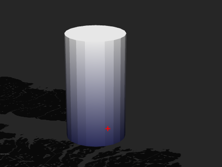
);toBar(coordinate: maptalks. Coordinate, options: BarOptionType, THREE.Material)
export type BarOptionType = BaseObjectOptionType & {
    radius?: number;
    height?: number;
    radialSegments?: number;
    topColor?: string;
    bottomColor?: string;
};

const bar = threeLayer.toBar(
    [120, 31],
    {
        radius: 100,
        height: 100,
    },
    material
);
toLine(lineString: LineStringType, options: LineOptionType, THREE.Material: LineMaterialType)
export type LineOptionType = BaseObjectOptionType & {
    bottomHeight?: number;
    colors?: Array<string | THREE.Color>;
};
const line = threeLayer.toLine(
    new maptalks.LineString(coordinates),
    {},
    material
);
toExtrudeLine(lineString: LineStringType, options: ExtrudeLineOptionType, THREE.Material)
export type ExtrudeLineOptionType = BaseObjectOptionType & {
    bottomHeight?: number,
    width?: number,
    height?: number,
    topColor?: string,
    bottomColor?: string,
    key?: string,
    pathUV?: boolean
}
const line = threeLayer.toExtrudeLine(
    new maptalks.LineString(coordinates),
    {
        width: 5,
        height: 1,
    },
    material
);
toModel(model: THREE.Object3D, options: BaseObjectOptionType)
    var loader = new THREE.GLTFLoader();
    loader.load('./data/RobotExpressive.glb', function(gltf) {

        const model = gltf.scene;
        model.rotation.x = Math.PI / 2;
        model.scale.set(100, 100, 100);

        baseObjectModel = threeLayer.toModel(model, {
            coordinate: map.getCenter()
        });
        // model.position.copy(threeLayer.coordinateToVector3(map.getCenter()));
        threeLayer.addMesh(baseObjectModel);

    }, undefined, function(e) {

        console.error(e);

    });
toExtrudeLineTrail(lineString: SingleLineStringType, options: ExtrudeLineTrailOptionType, THREE.Material)
export type ExtrudeLineTrailOptionType = BaseObjectOptionType & {
    trail?: number,
    chunkLength?: number,
    width?: number,
    height?: number,
    speed?: number,
    pathUV?: boolean
}

const line = threeLayer.toExtrudeLineTrail(
    new maptalks.LineString(coordinates),
    {
        width: 5,
        height: 1,
        chunkLength: 50,
        trail: 5,
    },
    material
);
DANGER
Considering performance issues, it is not recommended to use it
toExtrudePolygons(polygons: Array<PolygonType>, options: ExtrudePolygonOptionType, THREE.Material)
export type ExtrudePolygonOptionType = BaseObjectOptionType & {
    height?: number,
    bottomHeight?: number,
    topColor?: string,
    bottomColor?: string,
    key?: string,
    top?: boolean
}
const polygon1=new maptalks.Polygon(coordinates);
const polygon2=new maptalks.Polygon(coordinates);

polygon1.setProperties({
    height: 30
});
polygon2.setProperties({
    height: 100
});

const polygons =[polygon1,polygon2];

const mesh = threeLayer.toExtrudePolygons(
    polygons,
    { interactive: true, topColor: "#fff" },
    material
);
meshs.push(mesh);
TIP
Please bring your own height value for each polygon data
toPoint(coordinate: maptalks. Coordinate, options: PointOptionType, THREE.Material: THREE. PointsMaterial)
export type PointOptionType = BaseObjectOptionType & {
    height?: number;
    color?: string | THREE.Color;
    size?: number;
    coords?: number[];
};

const point = threeLayer.toPoint([120, 31], {}, material);
DANGER
Suggest using maptalks Marker to display icon points
toBars(points: Array<BarOptionType>, options: BarOptionType, THREE.Material: THREE. Material)
export type BarOptionType = BaseObjectOptionType & {
    radius?: number;
    height?: number;
    radialSegments?: number;
    topColor?: string;
    bottomColor?: string;
};

const data = [
    {
        coordinate: [120,31],
        height: 1000,
        radius: 15000,
        radialSegments: 20,
    },
    {
        coordinate: [120,32],
        height: 1000,
        radius: 15000,
        radialSegments: 20,
    },
];

   const mesh = threeLayer.toBars(data, { interactive: true, asynchronous: true, topColor: "#fff" }, material);
   bars.push(mesh);
TIP
Please bring your own coordinates, height, etc. for each data
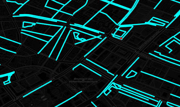
toExtrudeLines(lineStrings: Array<LineStringType>, options: ExtrudeLineOptionType, THREE.Material: THREE.Material)
export type ExtrudeLineOptionType = BaseObjectOptionType & {
    bottomHeight?: number,
    width?: number,
    height?: number,
    topColor?: string,
    bottomColor?: string,
    key?: string,
    pathUV?: boolean
}

const lineStrings=[
    new maptalks.LineString(coordinates),
    new maptalks.LineString(coordinates),
]
const mesh = threeLayer.toExtrudeLines(lineStrings, { interactive: true, minZoom: 11,width:5,height:1 }, material);
toLines(lineStrings: Array<LineStringType>, options: LineOptionType, THREE.Material: LineMaterialType)
export type LineOptionType = BaseObjectOptionType & {
bottomHeight?: number,
colors?: Array<string | THREE.Color>
}
const lineStrings=[
new maptalks.LineString(coordinates),
new maptalks.LineString(coordinates),
]
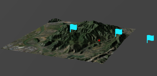
const mesh = threeLayer.toLines(lineStrings, { interactive: true, minZoom: 11 }, material);toTerrain(extent: maptalks.Extent, options: TerrainOptionType, THREE.Material: THREE.Material)
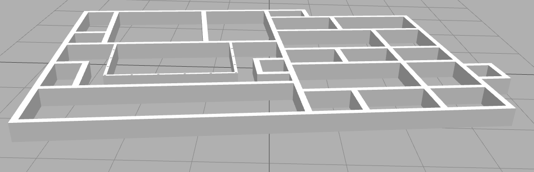
Create a simple terrain sand table effect
WARNING
Mainly used to create simple terrain sand tables, not suitable for loading large-scale terrain data
export type TerrainOptionType = BaseObjectOptionType & {
    image: ImageType,
    imageWidth?: number,
    imageHeight?: number,
    texture?: ImageType,
    flaserBoundary?: boolean,
    bufferPixel?: number
}

 const terrain = threeLayer.toTerrain(bbox, {
      flaserBoundary: false,
      bufferPixel: 0.2,
      image:'./data/tile-rgb.png',
      texture:'./data/tile-texture.png',
      imageWidth: TILESIZE,
      imageHeight: TILESIZE,
      altitude
  }, new THREE.MeshPhongMaterial({ color: terrainColor }));
the image data is mapbox terrain rgb tile data

tilebelt util can get tile bbox
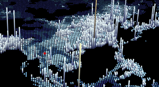
toHeatMap(data: Array<HeatMapDataType>, options: HeatMapOptionType, THREE.Material: THREE.Material)
Create Simple 3D HeatMap
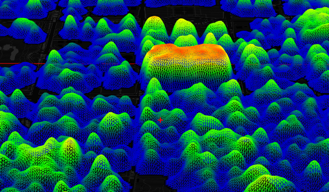
export type HeatMapDataType = {
    coordinate: maptalks.Coordinate | number[],
    count: number,
    lnglat?: maptalks.Coordinate | number[],
    xy?: maptalks.Coordinate | number[],
}

export type HeatMapOptionType = BaseObjectOptionType & {
    min?: number,
    max?: number,
    size?: number,
    gradient?: { [key: number]: any },
    gridScale?: number
}

let data = response.slice(0, 1 * 100000).map(d => {
    return {
        coordinate: [Number(d.lng), Number(d.lat)],
        value: Math.random() * 10,
        count: 30 * Math.random(),
    };
});
heatmap = threeLayer.toHeatMap(data, {
    gridScale: 2,
    size: 2,
    gradient: {
        0.25: 'rgb(0,0,200)',
        0.55: 'rgb(0,255,0)',
        0.85: 'yellow',
        1.0: 'rgb(255,0,0)'
    },
}, material);
threeLayer.addMesh(heatmap);
toFatLine(lineString: LineStringType, options: LineOptionType, THREE.Material: FatLineMaterialType)
export type LineOptionType = BaseObjectOptionType & {
    bottomHeight?: number,
    colors?: Array<string | THREE.Color>
}

  var material = new THREE.LineMaterial({
      color: 0x00ffff,
      transparent: true,
      // vertexColors: THREE.VertexColors,
      // side: THREE.BackSide,
      linewidth: 4 // in pixels
      // vertexColors: THREE.VertexColors,
      // dashed: false

  });

  var line = threeLayer.toFatLine(new maptalks.LineString(coordinates), {
      altitude: 0
}, material);toFatLines(lineStrings: Array<LineStringType>, options:LineOptionType, THREE.Material: FatLineMaterialType)
export type LineOptionType = BaseObjectOptionType & {
    bottomHeight?: number,
    colors?: Array<string | THREE.Color>
}

  var material = new THREE.LineMaterial({
      color: 0x00ffff,
      transparent: true,
      // vertexColors: THREE.VertexColors,
      // side: THREE.BackSide,
      linewidth: 4 // in pixels
      // vertexColors: THREE.VertexColors,
      // dashed: false

  });

  var line = threeLayer.toFatLines([new maptalks.LineString(coordinates)], {
      altitude: 0
  }, material);
toBox(coorindate: maptalks.Coordinate, options: BarOptionType, THREE.Material: THREE.Material)
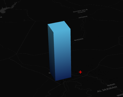
export type BarOptionType = BaseObjectOptionType & {
    radius?: number,
    height?: number,
    radialSegments?: number,
    topColor?: string,
    bottomColor?: string,
}

  var bar = threeLayer.toBox(d.coordinate, {
      height: d.height * 200,
      radius: 15000,
      topColor: '#fff',
      // radialSegments: 4
  }, material);
toBoxs(points: Array<BarOptionType>, options: BarOptionType, THREE.Material: THREE.Material)
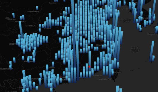
export type BarOptionType = BaseObjectOptionType & {
    radius?: number,
    height?: number,
    radialSegments?: number,
    topColor?: string,
    bottomColor?: string,
}
 const data = json.features.slice(0, Infinity).map(function(dataItem) {
     return {
         coordinate: dataItem.geometry.coordinates,
         height: Math.random() * 200,
         value: Math.random() * 10000,
         topColor: '#fff'
     }
 });
 const box = threeLayer.toBoxs(data, {}, material);
toPath(lineString: LineStringType, options: PathOptionType, THREE.Material: THREE.Material)
export type PathOptionType = BaseObjectOptionType & {
    bottomHeight?: number,
    width?: number,
    cornerRadius?: number,
    topColor?: string,
    bottomColor?: string,
    key?: string
}

var line = threeLayer.toPath(lineString, { altitude: Math.random() * 0.2, cornerRadius: 1, width: 8, asynchronous: true }, material);
toPaths(lineStrings: Array<LineStringType>, options: PathOptionType, THREE.Material: THREE.Material)
export type PathOptionType = BaseObjectOptionType & {
    bottomHeight?: number,
    width?: number,
    cornerRadius?: number,
    topColor?: string,
    bottomColor?: string,
    key?: string
}

var line = threeLayer.toPaths([lineString], { altitude: Math.random() * 0.2, cornerRadius: 1, width: 8, asynchronous: true }, material);
getBaseObjects()
getMeshes()
get all meshes.
WARNING
Native objects containing three, lights, etc
clear()
DANGER
Please use caution when clearing all graphic objects, including lights, etc
clearBaseObjects()
clearMesh()
getCamera()
getScene()
renderScene()
getThreeRenderer()
addMesh(meshes: Array<BaseObject | THREE.Object3D>, render: boolean = true)
const bar = threeLayer.toBar(coordinate, {}, material);
threeLayer.addMesh(bar);
removeMesh(meshes: Array<BaseObject | THREE.Object3D>, render: boolean = true)
identify(coordinate: maptalks.Coordinate | maptalks.Point, options: object)
map.on('click', e => {
    const baseObjects = threeLayer.identify(e.coordinate);
})